Smart mobility explainer
MWC Shanghai low-altitude economy explained: Why Drones Need Traffic Rules
The beginner version: the drone story is not only about flying robots. It is about giving low airspace traffic rules, identity, communication, and emergency plans.
MWC Shanghai low-altitude economy sounds like conference jargon, but the idea is simple: more useful machines may start sharing the air just above streets, warehouses, farms, ports, campuses, and cities.
At MWC26 Shanghai, GSMA source pages place drones, autonomous vehicles, mobile AI, connected infrastructure, and smart mobility on the same event agenda. The Smart Mobility Summit on June 25 specifically connects intelligent vehicles and the low-altitude economy with AI and connectivity.
BTI did not attend MWC Shanghai, test any drone, verify a flight, inspect an aircraft, or evaluate a commercial deployment. This guide translates public MWC Shanghai material and independent trade coverage into a plain-English map for normal readers.
- The low-altitude economy is the space where drones, eVTOL aircraft, sensors, networks, and traffic rules meet.
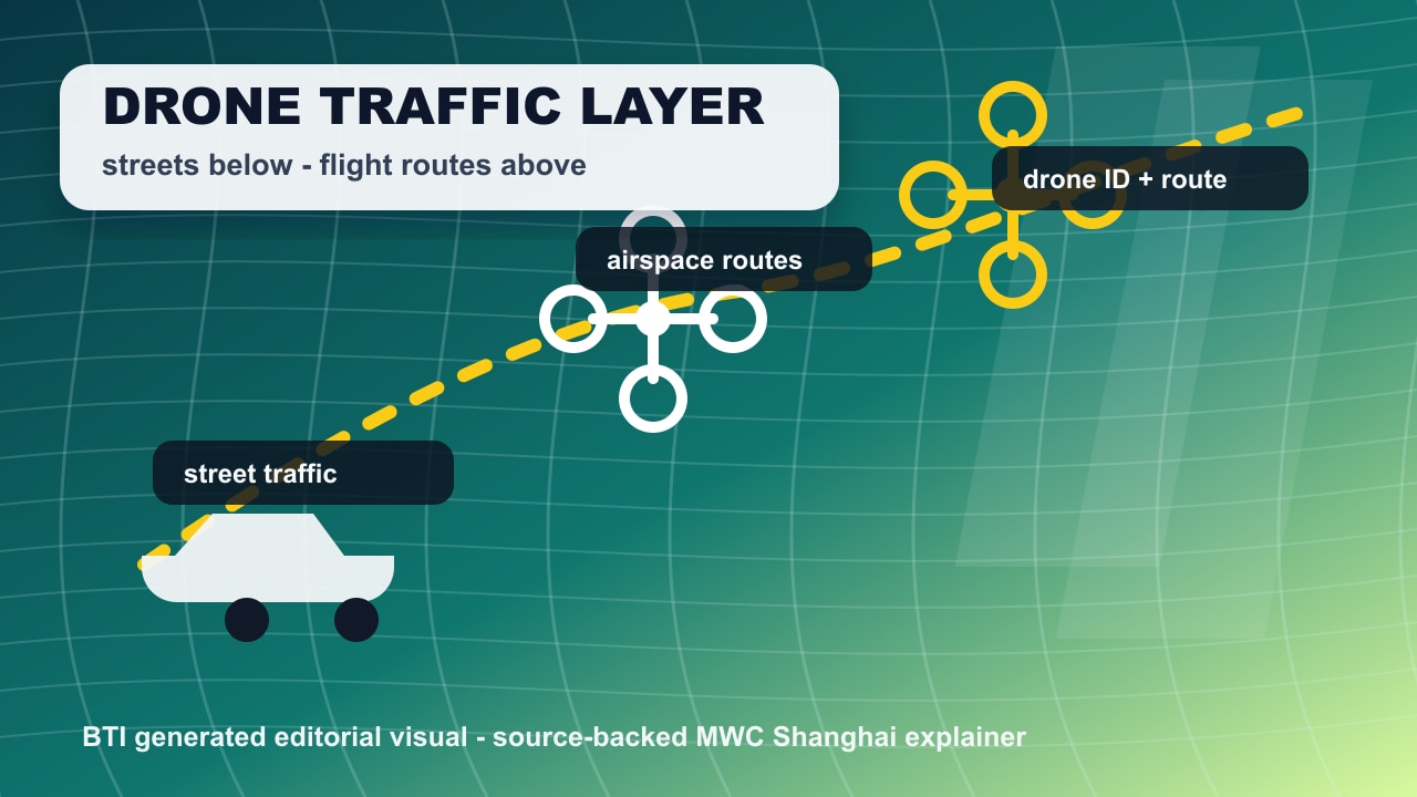
- The viral hook is not “drones are cool.” It is “cities may need a new traffic layer above the street.”
- The buyer-style question is whether the system can coordinate many aircraft safely, not whether one demo looks futuristic.
MWC Shanghai low-altitude economy quick answer
The low-altitude economy is the business and infrastructure layer around aircraft that fly close to the ground: drones, UAVs, eVTOL aircraft, inspection flights, delivery routes, emergency support, mapping, security, and smart-city services. The MWC Shanghai angle is that these systems need AI, connectivity, traffic management, and shared data before they can scale.
That is why this topic belongs on BTI. A beginner does not need a telecom vocabulary lesson. They need a simple mental model: if roads need lights, lanes, signs, maps, and dispatch systems, low-altitude aircraft need their own version of that stack.
The five traffic layers to understand
A single drone flight is easy to picture. The hard part starts when many aircraft, operators, routes, weather changes, buildings, people, emergency vehicles, and restricted zones all interact. That is the gap MWC Shanghai’s smart mobility agenda is pointing at.
| Layer | Plain-English meaning | Question to ask |
|---|---|---|
| Airspace lanes | Drones need a safe path through low airspace, just like cars need lanes and intersections. | Who decides which drone can use which route, altitude, and landing area? |
| Drone identity | A city-scale drone system has to know which aircraft is flying, who operates it, and whether it belongs there. | Can the network tell a delivery drone, inspection drone, and emergency drone apart? |
| Reliable links | Autonomous flight still depends on communication for positioning, updates, monitoring, and handoff between systems. | What happens if the link is weak, crowded, or blocked by buildings? |
| AI perception | The aircraft needs to sense people, buildings, weather, cables, birds, vehicles, and other drones. | Can the drone understand the real scene, not just follow a preplanned line? |
| Traffic management | The hard part is not one drone flying. It is many drones sharing routes, schedules, rules, and emergency plans. | Can the system coordinate normal trips, delays, restricted zones, and safety fallbacks? |
What the drone clip does not prove yet
The phrase low-altitude economy can make the whole topic sound distant. The everyday version is more practical: inspections can be faster, emergency views can arrive sooner, maps can update more often, warehouses can move goods differently, and future air-mobility systems may need to share routes with road vehicles and cloud services.
MWC Shanghai’s Smart Mobility Summit description ties the subject to AI perception, C-V2X, cloud-edge-vehicle intelligence, autonomous driving, eVTOL development, low-altitude traffic management, and air-ground-cloud communication networks. That is not one product category. It is a coordination problem.
For BTI readers, the useful takeaway is to separate the visible aircraft from the hidden system underneath. The aircraft gets the video. The system is what still has to earn trust at scale.
The stack behind a flying robot economy
The easiest way to follow the story is to split it into pieces. Each piece answers a different beginner question: What is flying? What can it see? How does it communicate? Who coordinates it? What happens when conditions change?
| Piece | Plain role | Why it matters |
|---|---|---|
| Drones and UAVs | Small aircraft doing inspections, deliveries, mapping, security, or emergency work. | They are the easiest way for normal readers to picture the low-altitude economy. |
| eVTOL aircraft | Electric aircraft designed for vertical takeoff and landing. | They move the conversation from hobby drones toward passenger or cargo air-mobility systems. |
| AI and perception models | Software that helps the aircraft understand the scene and react. | A flying robot has to decide in motion, not only follow a static route. |
| Connectivity | Mobile networks, satellite links, and edge systems that keep aircraft coordinated. | MWC’s angle is that flight, cars, cloud systems, and networks are becoming one mobility stack. |
| Air-ground-cloud coordination | Shared data between aircraft, roads, control systems, cloud services, and operators. | This is the hidden layer that makes the topic more than a cool drone clip. |
MWC Shanghai low-altitude economy FAQ
What does low-altitude economy mean?
It means services and infrastructure built around low-flying aircraft such as drones, UAVs, and eVTOL systems. The practical story is routes, rules, communication, coordination, and safety for aircraft operating closer to everyday places.
Why was this at MWC Shanghai?
MWC is a connectivity event. Drones and smart mobility depend on mobile networks, edge systems, cloud services, AI perception, and coordination between vehicles, aircraft, operators, and cities.
Is BTI saying these drone services are ready for public use?
No. BTI is explaining the public MWC Shanghai topic, not claiming availability, pricing, approval, performance, or hands-on testing of any specific service.
Sources for this MWC Shanghai low-altitude economy guide
This explainer is based on public source pages and independent trade coverage. BTI did not add unpublished claims, availability claims, performance claims, prices, ratings, reviews, awards, or hands-on testing claims.
- GSMA MWC26 Shanghai opening announcement: Confirms MWC26 Shanghai opened on June 24, 2026 and frames AI, robotics, drones, autonomous vehicles, and connectivity as central event themes.
- MWC Shanghai Smart Mobility Summit agenda: Lists the June 25 smart mobility session on intelligent vehicles and the low-altitude economy through AI and connectivity.
- MWC Shanghai Mobile AI Innovation Frontiers: Describes a full-stack mobile AI zone covering chipsets, AI servers, frontier models, AI-native hardware, and humanoid robots.
- Mobile World Live MWC Shanghai coverage: Independent trade coverage of GSMA’s MWC Shanghai keynote focus on robotics, drones, low-altitude services, autonomous vehicles, and connected systems.
- IoT Now MWC26 Shanghai preview: Highlights the event’s everyday-life technology themes, including 6G, mobile AI, embodied intelligence, smart healthcare, smart mobility, satellite, and NTN.
What normal readers should watch next
When the next drone, eVTOL, or connected-car headline appears, skip the futuristic language for a moment and look for the proof points. Does the story explain traffic management? Does it name the communication layer? Does it mention emergency fallback? Does it explain whether the aircraft can sense and react, or whether it only follows a narrow preplanned route?
Those questions make the topic more concrete. They also keep BTI away from overclaiming. A conference agenda can show direction. It does not prove that every drone service is safe, approved, available, or commercially mature.
The strongest Instagram version should show a simple airspace map: street traffic below, drones above, cloud and network coordination around them, and one clear promise: the future of mobility may need a new traffic layer.
Follow BTI for the next plain-English tech breakdown
BTI turns current tech stories into simple buyer and science explainers without claiming hands-on testing, prices, ratings, or availability.